PhD Thesis: A Data-Driven Investigation on Urban Form Evolution
For my doctoral research at the University of Melbourne, I built longitudinal urban form datasets for three iconic grid cities — New York, Melbourne, and Barcelona — to understand how existing patterns of buildings, plots, and streets shape where transformation happens next, and where things simply stay put.

Something that has always fascinated me about cities is how change and persistence happen at the same time, right next to each other. A street layout from the 1800s quietly shapes which buildings get replaced a century later, while directly adjacent blocks barely change at all, one reinventing itself continuously, the other frozen. The physical form of a city, its plots, buildings and streets, is not a passive container where social and economic processes simply play out, nor is it merely their residue. It actively sets the conditions that constrain some futures while opening up others.
One of the most influential empirical contributions to this question came from Anne Vernez Moudon, whose Alamo Square study in San Francisco traced the resilience and processes of change in fine-grained urban fabric through extensive longitudinal mapping. I was tremendously lucky that she was one of the reviewers of my thesis, bringing extensive, wise and generous insights that shaped the final version in ways I am still grateful for. We lost her in 2025, and the field is much poorer for it.
The concept of change sits at the centre of urban morphology more broadly, running through the work of M.R.G. Conzen, Jeremy Whitehand and Brenda Scheer among others. Yet despite this theoretical richness, the question received less empirical attention as the field became more data-driven. Most data-centric urban form studies remain synchronic: they capture a single moment and simply ignore time. Building on the recently advancing field of morphometrics, I wanted to bring a more rigorous, time-conscious and quantitative perspective to this old question: how do urban form conditions affect where change happens, and where things persist?
Why Urban Grids? Resolving a Paradox
I consciously focused on urban grids, the ultimate spatial signature of rational planning and top-down design. The choice was intentional: to confront a paradox. Top-down design does not exclude change. Depending on formal conditions, it can actively facilitate it, or resist it. This is where the study bridges urban design and urban morphology, advancing the argument that designed spatial conditions should be understood as infrastructures for future evolution, not just fixed arrangements. Some should allow more change. Others should lead to freezing. And knowing which is which matters.
Manhattan's 1811 Commissioners' Plan, Hoddle's 1837 Melbourne survey, Cerdà's 1859 Barcelona extension: all were conceived as rational, preconceived frameworks. Yet portions of each evolved into intricate, adaptable urban fabrics while other areas stagnated. The difference is not written in economic forces or planning policies alone. It is in the physical form itself. Plot sizes, building densities, street configurations: not passive outcomes of urban change, but active conditions shaping what becomes possible next.
Three Grid Cities, Four Time Frames, Two Centuries of Evolution
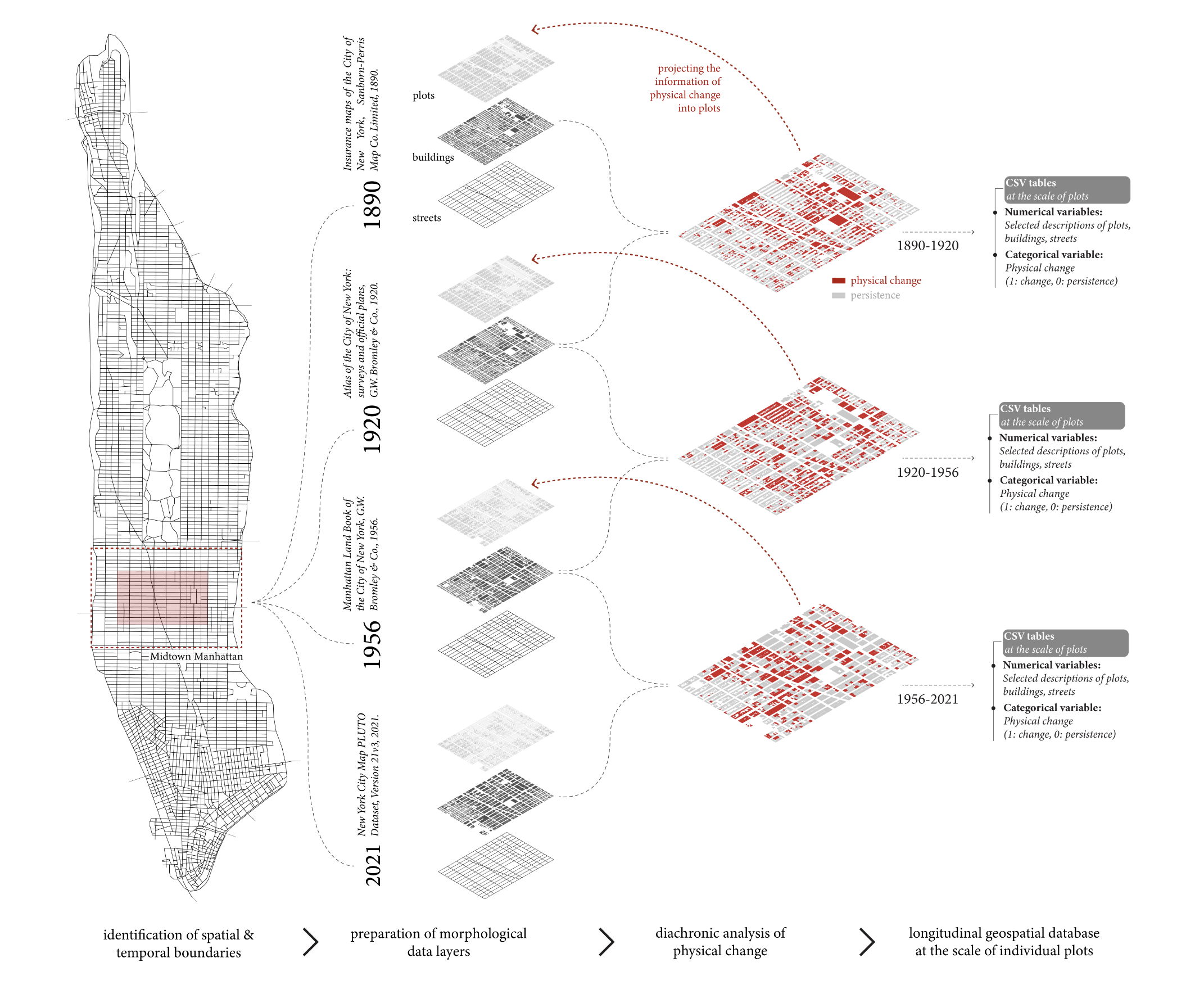
I chose three specific sections for comparability and contrast: Midtown Manhattan, the City Centre of Melbourne, and the Eixample district of Barcelona. All three iconic grids were laid out in roughly the same era, yet they evolved under vastly different circumstances on three different continents, making the comparison both meaningful and revealing.
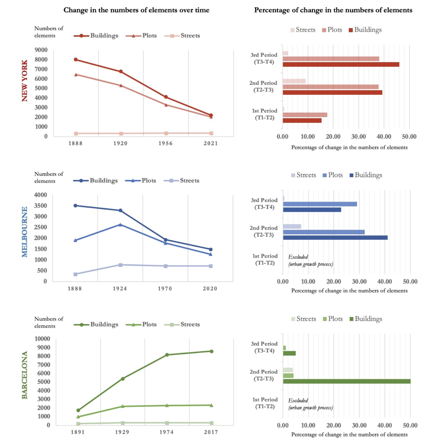
Each case was analyzed across four successive time frames from the early 1800s to the 2000s, producing twelve spatial snapshots. Manhattan coarsened and shot upward: the number of available parcels dropped 70%, average plot size tripled, and extreme vertical densification reshaped the third dimension entirely. Melbourne's exceptionally large blocks necessitated something remarkable, the bottom-up, unplanned emergence of intricate internal laneway networks that are now one of the city's most distinctive spatial signatures. Barcelona, by contrast, held its modular plot structure and courtyard block typology across more than a century of slow, persistent evolution.
Three comprehensive longitudinal datasets were compiled from historical maps, plans, aerial photos and geospatial databases, which required me to spend countless hours digitising buildings, plots and streets into vector format. Yes. This was just before everything changed dramatically with the arrival of AI-powered segmentation and generative tools. Painstaking at the time, but it produced a promising dataset that makes this research possible.
Morphometrics Extended into Diachronic Analysis
The analytical framework had three steps. Quantifying urban form conditions at each time frame using measures of plots, buildings and streets came first. Then came the mapping: what changed between periods through physical transformation (demolition and construction) and what shifted functionally (land use transitions without physical alteration). Statistical analysis then revealed the relationships between form conditions and spatial dynamics. Which morphological conditions systematically predicted change? Which ones anchored persistence? That is what the analysis was designed to uncover.
Urban Form is Influential on Change and Persistence
The most important finding reframes where we should look. Urban morphology has long relied on metrics describing the character of individual elements: a single plot's size, a building's coverage ratio, a street's width. But change is a relational phenomenon, shaped by a neighbour effect, where surrounding form conditions matter as much as the element's own properties. My research examined this directly, and the findings are consistent across all three cities.
The most reliable predictors of physical change were not individual plot characteristics but accessibility-based descriptions of the surrounding pattern, particularly accessible plot density and accessible plot frontage within a 400-metre catchment. Fine-grained plot structures underwent less physical change while coarser, broader configurations changed more frequently. Individual plot size on its own proved a consistently poor predictor.
Built density showed a negative relationship with change everywhere: low GSI and FSI conditions changed more frequently. Lower density signals underutilised land, and underutilised land invites more drastic transformation in the next period. Dense, already built-out fabric resists wholesale redevelopment.
Street centrality positively influenced change in Manhattan and Barcelona, where more integrated street segments attracted more transformation in their surroundings. In Melbourne this relationship broke down, a consequence of the distinctive laneway network redistributing accessibility in ways that standard centrality measures fail to capture.
For functional change, size mattered differently. Smaller plots proved capable of accommodating a far wider range of uses over time. As plot size increases, elements tend to be purpose-built for specific functions and become far less adaptable to others. Traditional low-rise typologies showed considerably more functional flexibility than modern high-rises designed around a single programme.
Urban Form Elements Have Universal Rates of Change
Another finding that held consistently across all three contexts: urban form elements have inherent rates of change, and these rates are remarkably universal. Streets were the most persistent element, with only 4–7% change over more than a century. Plots were more changeable but still relatively permanent. Buildings were the most transient, turning over far more rapidly. This hierarchy of persistence held across Manhattan, Melbourne and Barcelona alike. The coexistence of these fast and slow variables is, I think, what gives cities their capacity to adapt while remaining structurally recognisable, what lets a city keep reinventing parts of itself without losing its underlying character.
What This Opens Up: Designing for Evolution, Not End-States
This thesis strengthens an evolutionary understanding of cities: design does not exclude change, but may actively favour it depending on formal conditions. Rather than chasing ideal end-states, the more productive question is what spatial preconditions enable adaptive evolution. Fine-grain plot structures, mixed building densities, permeable street networks: these are not aesthetic preferences. They are infrastructures for long-term adaptability. Designing cities for change means recognising these conditions deliberately and paving the way for them, creating the spatial foundations that open futures rather than foreclose them.
Awards, Recognition and Publications
I am grateful to the University of Melbourne for the generous support that made this research possible, and for the environment at the Melbourne School of Design, a stimulating, productive four or five years in the southern hemisphere that I look back on with genuine fondness.
A few awards emerged from this work, and it means a great deal to see devoted research recognised more widely: the Melbourne Research Scholarship (2019–2023), the Melbourne Centre for Data Science Doctoral Academy Fellowship (2022–2023), the Bharat Dave Prize from MSD for Innovation in Research Design (2023), and the ABP Dean's Prize for Published Postgraduate Research as sole author (2023).
The thesis was supervised by an exceptional duo whose influence continues in my ongoing work. Prof. Justyna Karakiewicz brought the perspective of an architect and urban designer; Dr. Fjalar de Haan brought the rigour of a physicist and computational scientist working on societal transitions. I was also fortunate to have a committee to whom I am genuinely indebted: Prof. Anne Vernez Moudon (University of Washington), Prof. Brent Ryan (MIT), Prof. Christiane Herr (SUSTech), Prof. Alan March (UniMelb), and Dr. Elek Pafka (UniMelb).
Parts of this thesis, and further work that emerged from it, have been published in leading journals including Cities, Environment and Planning B, and Urban Morphology. You will find them in the Publications section.